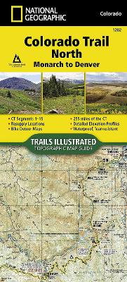
- Waterproof - Tear-Resistant - Topographic Map The Colorado Trail North Topographic Map Guide has been designed as the perfect traveling companion when navigating the north section of The Colorado Trail. In a state known for its trails, The Colorado Trail is Colorado's premier long distance trail. Conceived in 1973 and completed in 1987, the trail runs 486 miles between Denver and Durango, traversing some of the most spectacular scenery in the state. The Colorado Trail is often started at its north terminus in ...
Read More
- Waterproof - Tear-Resistant - Topographic Map The Colorado Trail North Topographic Map Guide has been designed as the perfect traveling companion when navigating the north section of The Colorado Trail. In a state known for its trails, The Colorado Trail is Colorado's premier long distance trail. Conceived in 1973 and completed in 1987, the trail runs 486 miles between Denver and Durango, traversing some of the most spectacular scenery in the state. The Colorado Trail is often started at its north terminus in Waterton Canyon just outside of Denver. When traveling from north to south the trail follows the South Platte River and quickly climbs into the Lost Creek Wilderness. From here the trail crosses into Holy Cross Wilderness near Leadville. The trail then skirts the eastern slope of the Sawatch Range and passes beneath Mount Elbert, the highest mountain in Colorado. Next comes the Collegiate Peaks Wilderness with its multiple 14ers before finally joining with the Collegiate Loop near Monarch Pass. The Colorado Trail from Monarch to Durango is then picked up on the south Topographic Map Guide . Each page is centered on the trail and overlaps with adjacent pages so there is little chance of getting lost. Along the bottom of each page is a trail profile that shows the distance between passes, camping areas, and trail access points. The map and trail profile provide a step by step visual guide to hiking the trail, mile by rugged mile. Expertly researched and created in partnership with local land management agencies including The Colorado Trail Foundation, this map guide provides detailed topographic maps, interesting history, bike detour maps, and a resupply location chart shows distances, and services available at each resupply point. More convenient and easier to use than folded maps, but just as compact and lightweight, National Geographic's Topographic Map Guide booklets are printed on "Backcountry Tough" waterproof, tear-resistant paper with stainless steel staples. A full UTM grid is printed on the map to aid with GPS navigation. Map Scale = 1:75,000 Folded Size = 4.25" x 9.38"
Read Less
Add this copy of Colorado Trail North, Monarch to Denver Map (National to cart. $17.05, very good condition, Sold by Goodwill of Colorado rated 5.0 out of 5 stars, ships from COLORADO SPRINGS, CO, UNITED STATES, published 2017 by National Geographic Maps.
Choose your shipping method in Checkout. Costs may vary based on destination.
Seller's Description:
Very good. This item shows limited signs of wear overall with minor scuffs or cosmetic blemishes. No curled corners, bent covers or damage to dust jackets. No highlighting/ writing in pages. Digital codes may not be included and have not been tested to be redeemable and/or active. Please note that all items are donated goods and are in used condition. Orders shipped Monday through Friday! Your purchase helps put people to work and learn life skills to reach their full potential. Orders shipped Monday through Friday. Your purchase helps put people to work and learn life skills to reach their full potential. Thank you!
Add this copy of Colorado Trail North, Monarch to Denver to cart. $21.42, new condition, Sold by Books2anywhere rated 5.0 out of 5 stars, ships from Fairford, GLOUCESTERSHIRE, UNITED KINGDOM, published 2017 by National Geographic Maps Division.
Choose your shipping method in Checkout. Costs may vary based on destination.
Seller's Description:
PLEASE NOTE, WE DO NOT SHIP TO DENMARK. New Book. Shipped from UK in 4 to 14 days. Established seller since 2000. Please note we cannot offer an expedited shipping service from the UK.
Add this copy of Colorado Trail North, Monarch to Denver to cart. $22.75, new condition, Sold by Paperbackshop International rated 2.0 out of 5 stars, ships from Fairford, GLOS, UNITED KINGDOM, published 2017 by National Geographic Maps Division.
Choose your shipping method in Checkout. Costs may vary based on destination.
Seller's Description:
PLEASE NOTE, WE DO NOT SHIP TO DENMARK. New Book. Shipped from UK in 4 to 14 days. Established seller since 2000. Please note we cannot offer an expedited shipping service from the UK.
Add this copy of Colorado Trail North, Monarch to Denver Map (National to cart. $37.84, good condition, Sold by Bonita rated 4.0 out of 5 stars, ships from Santa Clarita, CA, UNITED STATES, published 2017 by Natl Geographic Society Maps.
Add this copy of Colorado Trail North, Monarch to Denver to cart. $38.74, new condition, Sold by Paperbackshop rated 4.0 out of 5 stars, ships from Bensenville, IL, UNITED STATES, published 2017 by National Geographic Maps Division.
Add this copy of Colorado Trail North, Monarch to Denver Map (National to cart. $52.08, new condition, Sold by BetterBookDeals rated 3.0 out of 5 stars, ships from Toronto, ON, CANADA, published 2017 by Natl Geographic Society Maps.
Add this copy of Colorado Trail North, Monarch to Denver Map (National to cart. $61.32, new condition, Sold by Bonita rated 4.0 out of 5 stars, ships from Santa Clarita, CA, UNITED STATES, published 2017 by Natl Geographic Society Maps.
Add this copy of Colorado Trail North, Monarch to Denver Map (National to cart. $65.97, new condition, Sold by Just one more Chapter rated 3.0 out of 5 stars, ships from Miramar, FL, UNITED STATES, published 2017 by Natl Geographic Society Maps.


![Appalachian Trail, Springer Mountain to Davenport Gap [georgia, North Carolina, Tennessee]](https://www2.alibris-static.com/appalachian-trail-springer-mountain-to-davenport-gap-georgia-north-carolina-tennessee/isbn/9781597756389.gif)
![Appalachian Trail, Calf Mountain to Raven Rock [virginia, West Virginia, Maryland]](https://www1.alibris-static.com/appalachian-trail-calf-mountain-to-raven-rock-virginia-west-virginia-maryland/isbn/9781597756426.gif)
![Appalachian Trail, Davenport Gap to Damascus [north Carolina, Tennessee]](https://www0.alibris-static.com/appalachian-trail-davenport-gap-to-damascus-north-carolina-tennessee/isbn/9781597756396.gif)
![Appalachian Trail, Bailey Gap to Calf Mountain [virginia]](https://www0.alibris-static.com/appalachian-trail-bailey-gap-to-calf-mountain-virginia/isbn/9781597756419.gif)
![Appalachian Trail, Mount Carlo to Pleasant Pond [maine]](https://www2.alibris-static.com/appalachian-trail-mount-carlo-to-pleasant-pond-maine/isbn/9781597756495.gif)
![Appalachian Trail, Hanover to Mount Carlo [new Hampshire]](https://www2.alibris-static.com/appalachian-trail-hanover-to-mount-carlo-new-hampshire/isbn/9781597756488.gif)