This work features 4 sheets at a very detailed scale of six inches to the mile. The massive expansion of the Victorian age produced a demand for detailed maps to determine ownership of land and to plan development. Edward Stanford, a leading Victorian cartographer, produced these maps to show the railways, factories, docks and roads that were springing up everywhere. So detailed are these maps that even individual gardens of suburban homes are shown as are separate platforms of the new railway termini and, astonishingly, ...
Read More
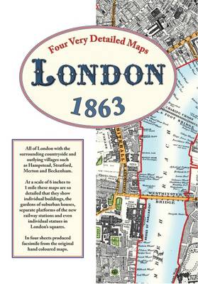
This work features 4 sheets at a very detailed scale of six inches to the mile. The massive expansion of the Victorian age produced a demand for detailed maps to determine ownership of land and to plan development. Edward Stanford, a leading Victorian cartographer, produced these maps to show the railways, factories, docks and roads that were springing up everywhere. So detailed are these maps that even individual gardens of suburban homes are shown as are separate platforms of the new railway termini and, astonishingly, even the individual statues in the city's squares. Anyone seeking information about their forebears will be able to see the roads, alleyways and outlying villages where they lived; where they went to school; the pubs where they spent their meagre wages; the churches and chapels where they were married and where they attended Sunday services; the factories, docks and farms where they worked; also maybe the miserable workhouses where they ended their days and the burial grounds where they were laid to rest. Local historians will find fields separating Hampstead and Kilburn with just the occasional farm; footpaths wandering through open country between Peckham and Dulwich. Closer to the centre, the main activity in Parsons Green is market gardening and in Kentish Town there was a vast slaughterhouse, with separate sections for sheep and cattle, close to the suitably named Butcher's Arms public house. Factories for making calico, lead shot, turpentine and candles as well as distilleries and breweries are marked and along the river are docks and factories for timber, flour and all the commodities newly arrived from the rapidly growing empire. Large houses, just one deep, face onto Clapham Common with farmland at the end of their large gardens. Numerous prisons, asylums and orphanages are shown as well as institutions such as The Soldiers Daughter's Home, The Aged Governess Asylum and a Female Reformatory. The early railways are marked as are the houses of famous people such as Sir Rowland Hill the social reformer who invented the postal service. Noticing what is marked is often as fascinating as seeing what has not yet been developed and together they provide a fascinating glimpse of Mid Victorian London.
Read Less
Add this copy of London Street Maps 1863 to cart. $98.42, good condition, Sold by 84 Charing Cross Road Books rated 5.0 out of 5 stars, ships from Cambridge, CAMBS, UNITED KINGDOM, published 2007 by Old House Books.
Choose your shipping method in Checkout. Costs may vary based on destination.
Seller's Description:
Good Condition. 9781873590645. Good+ 2007 Old House set of 4 maps, housed in outer box. Some creasing and squashing to outer box with curling and wear to top corners of lid of box, maps themselves very bright and unmarked. Quantity Available: 1. Shipped Weight: Under 1 kilogram. Category: Geography & Maps; ISBN: 1873590644. ISBN/EAN: 9781873590645. The book is available to view in-person at our Cambridge hub. The photos provided are of the actual book for sale, further condition-specific photos may be arranged upon request. Inventory No: 080227.
Add this copy of London Street Maps 1863 to cart. $119.44, very good condition, Sold by 84 Charing Cross Road Books rated 5.0 out of 5 stars, ships from Cambridge, CAMBS, UNITED KINGDOM, published 2007 by Old House Books.
Choose your shipping method in Checkout. Costs may vary based on destination.
Seller's Description:
Very Good Condition. 9781873590645. VG 2007 Old House set of 4 maps, housed in outer box. Some shelf-wear to outer box, maps themselves very bright and unmarked. Quantity Available: 1. Shipped Weight: Under 1 kilogram. Category: Geography & Maps; ISBN: 1873590644. ISBN/EAN: 9781873590645. The book is available to view in-person at our Cambridge hub. The photos provided are of the actual book for sale, further condition-specific photos may be arranged upon request. Inventory No: 080228.
Add this copy of Stanford's Library Maps of London and Its Suburbs (1863 to cart. $31.88, very good condition, Sold by John C. Newland rated 4.0 out of 5 stars, ships from Cheltenham, Glos., UNITED KINGDOM, published 2007 by Old House Books.
Add this copy of Four Very Detailed London Maps 1863: All of London and to cart. $131.91, good condition, Sold by Bonita rated 4.0 out of 5 stars, ships from Santa Clarita, CA, UNITED STATES, published 2009 by Old House Books.